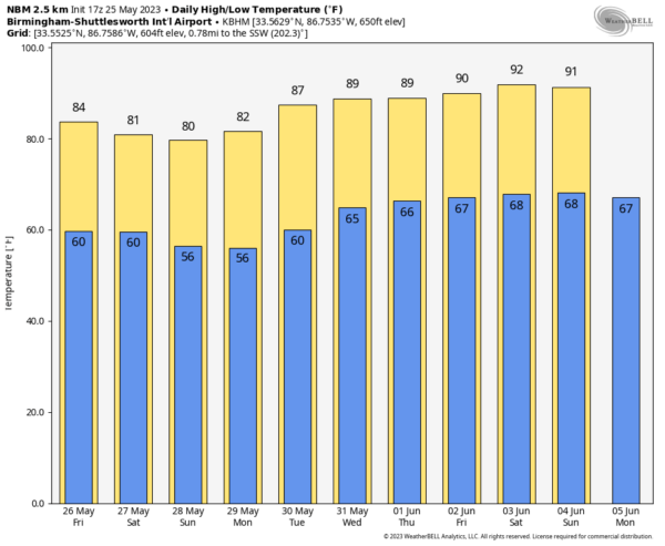
WARM MAY DAY: Temperatures are mostly in the low to mid 80s across Alabama this afternoon with hazy sunshine. Smoke from Canadian wildfires has moved into the Deep South in the higher levels of the atmosphere, making for the hazy appearance today. There is nothing on radar, and tonight will be mostly fair with a low between 58 and 62 degrees.
Look for a partly sunny sky Friday with a high in the low 80s; showers will be few and far between during the afternoon and evening.
MEMORIAL DAY WEEKEND: A quiet pattern will continue across the Deep South over the holiday weekend. We are forecasting partly sunny days, fair nights and only isolated showers each day. The chance of any one community seeing rain will be 15-25% daily. Temperatures will be below average; we are looking at highs between 75 and 80 degrees Saturday, and in the low to mid 70s Sunday. Monday’s high will be close to 80.
REST OF NEXT WEEK: There’s still no sign of any high-impact weather event for Alabama through the week. Showers will remain isolated, and there will be a warming trend. Highs will be close to 90 by the end of the week.
 TROPICS: Disorganized showers and thunderstorms off the coast of the southeastern United States are associated with a front and trough of low pressure. A non-tropical area of low pressure is expected to form along the frontal boundary within the next day or so. The system appears unlikely to become a subtropical or tropical cyclone since it is forecast to remain frontal while moving generally northward and inland over the Carolinas this weekend.
Regardless, the system is likely to produce gusty winds and dangerous surf and rip-current conditions along portions of the southeastern U.S. late this week and into the weekend. Heavy rainfall is expected in portions of the Carolinas, with hazardous marine conditions expected over the coastal and offshore waters, where gale warnings are in effect.
Hurricane season in the Atlantic basin begins one week from today, on Thursday, June 1.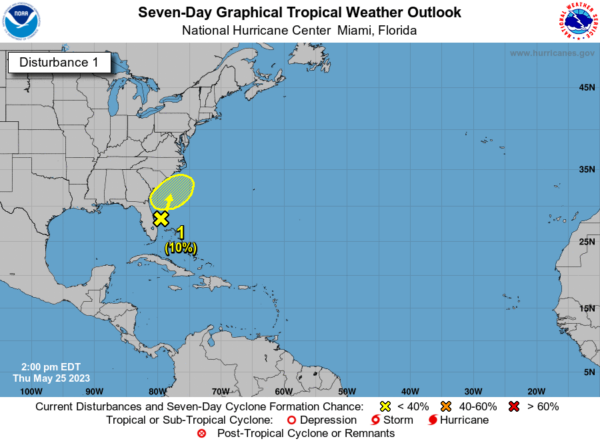 ON THIS DATE IN 1955: An estimated F5 tornado moved through the heart of Blackwell, Oklahoma. About 400 homes were destroyed, and many were leveled and swept away. About 500 other homes were damaged. The tornado dissipated just over the Kansas border, as the Udall, Kansas, tornado was forming to the east. The Blackwell tornado was accompanied by unusual electrical activity; the funnel was said to glow and have arcs of light. The Udall tornado was estimated to be an F5 as well.
ON THIS DATE IN 2008: A large, destructive EF5 tornado created a 43-mile-long path across Butler and Black Hawk counties in Iowa. This tornado killed eight people, injured dozens and caused several million dollars in damage.
For more weather news and information from James Spann and his team, visit AlabamaWx.