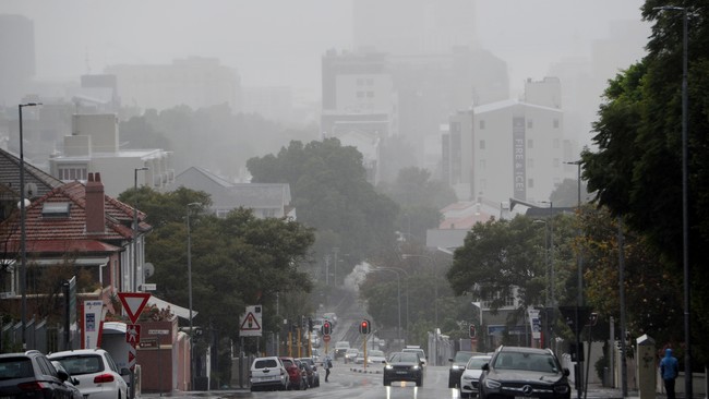

Cape Town – Residents in the Western Cape have been told to keep warm as an intense cold front is expected to make landfall on Wednesday evening.
According to the South African Weather Service (SAWS), residents can expect a few days of wet, windy and cold weather in the southern high-lying areas in the Namakwa region and the interior of the province.
The cold front is expected to make landfall over the south-western parts of the Western Cape, with rains and showers to follow into Thursday which would spread to the east.
Rain is expected to cease on Thursday evening with intense cold temperatures persisting into Friday morning.
Temperatures are expected to drop below 10°C with between 30mm and 40mm of rainfall expected over the mountainous areas of the Cape Metropole and southern parts of the Cape Winelands.
The weather service said cold temperatures would recover from the afternoon.
A warning has been issued for disruptive rain which could result in flooding of roads and settlements (formal and informal).
“Due to flooded roads, significant traffic disruption and motor vehicle accidents are likely, especially in peak hours of traffic. Disruption to essential services supply can be expected. Mudslides and/or rockfalls are also possible.
“If possible, stay indoors and off the roads, avoid crossing rivers and swollen streams where water is above your ankles. If trapped in a vehicle during a flood, abandon it and climb to higher ground. In buildings, move valuables to a safe place above the expected flood level.
“Switch off electricity at the supply point to the building. In rural areas, protect/relocate animals to a safe place on higher ground. Be especially cautious at night when it’s harder to recognise flood dangers.
“Listen to the radio or TV for warnings and obey the instructions from disaster management officers,” the weather service advised.
It also issued a warning for disruptive waves along the coastal parts of the province.
“Difficulty in navigation at sea for small vessels and personal watercrafts (e.g. kayaks) due to quick, successive steep waves is likely. These vessels will also be at risk of taking on water and capsizing in locality. Localised disruptions to small harbours and ports as well as beachfront activities are possible.”
It advised small boats and personal watercraft be kept away from the open sea and sheltered in a harbour, river estuary or protected bay.
“The public, especially tourists that are not familiar with the coastal routes where a build-up of sand is expected, are advised to seek alternative routes beforehand. Be aware of large unpredictable waves along the coast,” the weather service said.
[email protected]
IOL